Overview |
 Comments (0) |
 Ratings (0) |
 Download |

|
||||||||||||||||||||
|
Search
Software
Advertisements!
Free-downloads
|
Options for GridImp
Advertisement
GridImp
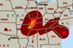
 Imports gridded data into Microsoft MapPoint, to produce attractive data maps that resemble contour maps.
 Can handle imperfect data, holes, re-gridding, etc. Can be used to import such attributes as pollution data, seismic hazard, geological information, customer/population distribution, etc. Data can be interpolated to different grid spacings if required. Polygon optimization algorithms reduce the drawing time, as well as GridImp's cpu and memory requirements. Various text formats supported using space, tab, or comma separators with both Unix and DOS/Windows newline conventions. Data coordinates can be longitude,latitude coordinates; custom linear coordinates; or UK Ordnance Survey Grid References. GridImp can add data to an existing map or template; allowing it to be used with such products as the Single State Mapper or other MapPoint add-ins. Predefined or user-defined color schemes can be used. These can include transparent 'gaps' as well as attractive color gradations. New version (v2.0) adds: Support for Ordnance Survey Grid References; Support for custom linear grids; support for existing map files; ability to force MapPoint garbage collection for large maps (reduces MapPoint's memory requirements, and increases speed). Advertisement
|
|||||||||||||||||||